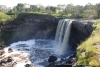
After visiting the Wannon Falls and the Nigretta Falls we went to the south from Hamilton town to the Byaduk Caves. The Byaduk Caves in Mt Napier State Park are the most extensive and accessible set of lava caves in Australia. Being so young (only 8000 years), they are largely unweathered and in their natural state. The caves are accessed through collapsed roof sections and display many well-preserved features left by the retreating and cooling lava. The largest tunnels are up to 18 metres wide, 10 metres high, and extend to depths of 20 meters below the surface.
Byaduk Caves are reached via the Byaduk Caves Road, 18 km from Hamilton on the Hamilton-Port Fairy Road.
Walking tracks follow cave edges and have a number of viewing points to observe flora, fauna and lava features.

During the summer you can climb down into Harmans One cave to get a good look at what's inside, although it's a tricky rocky path so you need to be extremely careful. In winter you can't climb down into the caves because of the Bentwing bats who live there. Their body systems are slowed down in what's known as torpor and if disturbed while in this state they can easily be killed.
It was very dark inside and we haven't had any torch, so we went to the next cave.

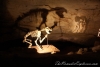
Harmans Two cave:

Closer:

It is very quiet and noone is around, except couple of sheep.

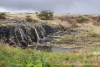
There is a lot of stone walls in that area. Using volcanic stones, early settlers build many dry stone walls in the mid-nineteenth century for crops, livestock, to contain rabbit plagues and for protection against fire.

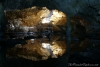
The Bridge Cave illustrates the tube formation more clearly by linking two of the large open holes in the ground. Do you see that light spot? It is a hole to the other side of the bridge.

Scoria:

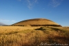
Mt Napier is the youngest volcano in Victoria and the highest volcanic point in the Western District Plains. The volcanic activity occurred less than 10,000 years ago. A major eruption of fluid basaltic lava for more than 24 kilometres along the valley of Harmans Creek/ The Byaduk Caves were formed by the Mt Napier lava flow.
The Aboriginal people would have watched in awe as the eruption of Mount Napier sent a scorching river of molten lava coursing into the Harmans Valley. They were in little danger as lava flows typically advance at about walking pace, although the lava stream in the main channel would have been faster. The Mount Napier Lava Flow followed the Harman Valley west from the volcano, and then south towards nearby Mount Eccles which is 25 km south-west of Mount Napier.
Mt. Napier, from Harman Valley Lookout:

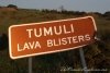
The next stop were lava blisters - tumuli. I will tell you about them in my next post.